 Access : Bibbiena is reached by car from Firenze by the highway n. 70
from Passo della Consuma and from Arezzo by the highway n. 71 from Passo
dei Mandrioli The little town is reachable also by train as there are
stations all along the Arezzo-Pratovecchio-Stia line. The exact starting
point of the itinerary is located on the highway n.71 near the locality
Corsalone. Here, right along the right hand bank of the stream Corsalone,
runs the unsurfaced road which will be used in the proposed itinerary.
Access : Bibbiena is reached by car from Firenze by the highway n. 70
from Passo della Consuma and from Arezzo by the highway n. 71 from Passo
dei Mandrioli The little town is reachable also by train as there are
stations all along the Arezzo-Pratovecchio-Stia line. The exact starting
point of the itinerary is located on the highway n.71 near the locality
Corsalone. Here, right along the right hand bank of the stream Corsalone,
runs the unsurfaced road which will be used in the proposed itinerary.
The itinerary is historic from all points of view. In fact, in runs the
total length of the road which goes up from Bibbiena to Verna and which
represented, until 60 years ago, the best connecting road between the
Casentinese valley and the Franciscan Hermitage. For this it is also probably
the road used by Campana to climb up to the Sanctuary after having gone
down to the "aretino" (of Arezzo) valley bottom, and exactly,
to Stia. (see itinerary n. 3) Many panoramic images along the route in
fact, bring to mind the Tuscan poet.
Going beyond the always open orange gate, a tranquil walk along the level
unsurfaced road, which heads towards Campi. The route to be taken is made
particularly evident by the frequent white/red signs of pathway n.043
CAI. Joined soon after by a bumpy tongue of asphalt, there follow to the
right quickly reaching the few houses of Campi sparse in the rural valley
bottom of the stream Corsalone. From here follow the asphalt to then turn
right on a straight little unmade upwards road which goes close to the
Corsalone. Having passed the latter (at one time by a bridge which collapsed
after a recent flood) begin to climb, immediately reaching an old rural
built up area. In this tract, the old road for La Verna is also particularly
evident in all its width and in its original paving.
After a short while the road, which in the meantime has been transformed
by overgrowing vegetation into a cramped mule track, meets the new asphalted
road which rises to Verna. This must be crossed to again follow, on the
opposite side, the paving of the ancient road. The track scrambles across
woody areas with bushy undergrowth, with some straight stretches towards
Case Nuove. In fact, having again met asphalt turn on this to the left
and, soon after, go between the houses of a little inhabited centre (still
following the white/red signs). Cross the highway and go up for a short
tract, outside the woods, keeping to the paved road which follows the
large crest overhanging the asphalt road.
Meeting the highway for the Nth time cross it again going on the opposite
side to find the narrow pathway which corresponds to the ancient road
to Verna. A few hundred metres are all that is necessary to return to
the asphalt, near a red house belonging to "Anas" (a state company
who maintain the highways). From here it is no longer possible to follow
faithfully the ancient road, it being too overgrown, but white/red signs
invite you to keep parallel to it following open fields used for grazing.
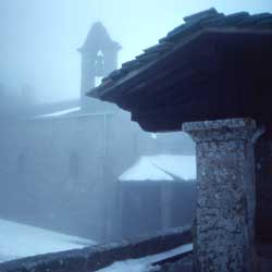
It is on this tract uphill that Verna appears, recorded by Campana as
"on the interminable stubble ever taller, the natural rocks emerged
like bulls to support the tiny convent which shone with rays of light
in its window settings".
With a last effort the highway is reached again right under the steep
rocks of Monte Penna, near the few old houses of Beccia. Leaving the highway,
you pass in fact among the houses, get onto the old road still paved,
which allows you to climb to Verna. After a few hundred metres you find
yourself in front of the front door of a Francescan hermitage, inside
which it is possible to find the "corridor where The Way of the Cross
of St Frances' life took place" and "other deep rock fissures
where a stone stairway goes deeply down in a shadow without memory".,
or feel "the icy breath of the caverns " and that "the
bell of the little Francescan church tings in the sadness of the cloister".
| Time required |
5.30 hours |
| Vertical height |
820 m |
| Maps |
Multigraphic 1 :25.000 n. 33-35 |
|
 www.terraditoscana.com