 Continuing
his descent into Inferno, and after having encountered Brunetto Latini,
he comes to the edge of the Seventh Circle, which is divided from the
Eighth by a stretch of rock down which the Flegetonte, one of the rivers
in Inferno, flows in a noisy waterfall. To make the image clearer, Dante
uses a simile, comparing the stair of rock and the sound of the Flegetonte
waterfalls to that of Acquacheta, a sizeable watercourse in Romagna which
flows into the river Montone. Rising in the Apennines on Monte Levane,
just before flowing by S. Benedetto in Alpe, it falls spectacularly from
a high crag of sandstone, splitting into a whole series of rushing streams. Continuing
his descent into Inferno, and after having encountered Brunetto Latini,
he comes to the edge of the Seventh Circle, which is divided from the
Eighth by a stretch of rock down which the Flegetonte, one of the rivers
in Inferno, flows in a noisy waterfall. To make the image clearer, Dante
uses a simile, comparing the stair of rock and the sound of the Flegetonte
waterfalls to that of Acquacheta, a sizeable watercourse in Romagna which
flows into the river Montone. Rising in the Apennines on Monte Levane,
just before flowing by S. Benedetto in Alpe, it falls spectacularly from
a high crag of sandstone, splitting into a whole series of rushing streams.
Come quel fiume c'ha proprio cammino
prima del Monte Viso 'nver levante,
da la sinistra costa d'Apennino,
che si chiama Acquacheta suso, avante
che si divalli giù nel basso letto,
e a Forlì di quel nome è vacante,
rimbomba là sovra San Benedetto
de l'Alpe per cadere ad una scesa
ove dovea per mille esser recetto;
così giù d'una ripa discoscesa,
trovammo risonar quell'acqua tinta,
si che 'n poc'ora avría l'orecchia offesa.
Like as that stream, whose separate waters glide
By their own channel from Mount Vesulo,
Eastward above the Apennines' left side,
On high call'd Acquacheta, ere the flow
Precipitant has reach'd its lowly bed,
No more at Forlì then that name to know;
Above San Benedetto, from her head
Sounds thundering headlong to a base, just where
Full many, in truth, might well be hous'd and fed;
So from the summit of the craggy stair
Such found we that ensanguin'd water's roar,
As in a little space no ears could bear.
(Inferno, Canto XVI, 94/105) |
Given the context, the reference to Monte Viso is hardly surprising.
Dante provides here one of the most precise geographical descriptions
in the whole of The Divine Comedy; he explains that the Acquacheta (and
therefore also the Montone) is the first of the rivers flowing down the
left-hand slopes of the Apennines that you come to heading east from Monviso
that has "its own path", that is flows directly into the sea
and not into the Po. That's in fact what happened 600 years ago, when
the river Reno had not yet been artificially deviated (it flowed into
the Po delta in Dante's time) and the river Lamone petered out into marshland
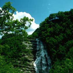
without directly reaching the sea. The fame of the Acquacheta waterfalls,
already well-known in the 14th century, has remained undiminished - indeed
has increased considerably - over the years, in part due to Dante's reference
to them in his work. The poet undoubtedly visited more than once the area
around S. Benedetto in Alpe. This area is particularly suitable for walking,
with its interesting steep-sloped mountains covered with beech and chestnut
trees dropping down into valley bottoms deeply etched by watercourses.
Water erosion has also revealed in many points the imposing strata of
sandstone that make up the backbone of the Romagna Apennines, creating
natural steps and spectacular rock features over which cascades flow.
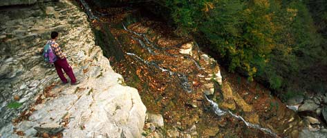
This walk is without doubt one of the least well-known in the area, and
allows you to get to the Acquacheta waterfalls from above (the more popular
path takes you to a point where you can view them from below), bringing
you, therefore, to the edge of the "Seventh Circle".
Park in the large parking area at S. Benedetto in Alpe and go back onto
the state road, turn right and cross the bridge over the Fosso Acqua Cheta.
Climb the steps on the right just after the bridge, which lead to a small
chapel and a clearly-defined path that runs along the right-hand side
of the mountain stream. The path was once marked by the CAI and the red
and white marks, though faded, are still a useful guide. After walking
for several hundred metres along the banks of the stream, you come to
a junction. Go left here on the path that climbs steeply and leaves the
stream. The path brings you to a point affected by a small landslide,
and takes you round it from above. The path continues in the chestnut
wood, mid-slope but climbing gradually to a small plateau where there
are a number of centuries-old chestnut trees. The path cuts across the
slope for a short while, then begins to climb onto one of the ridges coming
down from the Monte del Prato Andreaccio. The chestnut trees begin to
give way to beeches, some of which are columnar.
 When you reach what is clearly a pass, there are two options for reaching
the Case Monte di Londa. The first is unmarked and follows the line of
the crest, climbing up and beyond the peak of Prato Andreaccio and then
descending to the houses. The second, which is poorly-marked - the red
and white signs are very faded -, cuts across the northern slopes of the
mountain along the more-commonly used path that leads to the abandoned
Case Pian della Posta. Here you join a mule-track that takes you without
any great difficulty to the large grassy amphitheatre where there are
the Case Monte di Londa, which have also been abandoned. When you get
to these abandoned houses, the mule-track bends left and cuts across the
western slope of the Monte di Londa. Be particularly careful at the junction
a few hundred metres further on. Here you leave the main mule-track and
take the path to the right that leads onto the eastern side of the Balze
Trafossi (watch out for the CAI signs, which are useful here). From here
onwards the path begins to drop quite markedly, passing the house of Sodaccio
built on a rock outcrop and coming to the Fosso Acqua Cheta. Don't cross
it but carry on to the right until you come to an easy ford where you
can cross and get onto to smooth layers of sandstone that lead to the
main drop of the waterfall.
You then return the way you came, sticking to the left (orographically
speaking) of the mountain stream till you reach the grassy plateau of
the Romiti, where there are the ruins of an old convent perched on a small
rise. Don't cross the plateau but keep to the right of it, getting onto
the old mule-track that goes downhill and crosses the Fosso Cà
del Vento just beneath a noisy waterfall. Keep to the main mule-track
and soon you come to a natural balcony where you get an excellent view
of the whole Acqua Cheta waterfall. Carry on along the mule-track running
along the left-hand side of the valley; there's no danger of getting lost
as it's well-marked and much used. Along the way there are lots of points
where you can get to the stream, and there are plenty of stretches of
rock and small cool pools. The track finally joins the asphalt road linking
S. Benedetto and Marradi. Go right along the road which brings you back
down to the starting point.
| Time required |
4 hours |
| Vertical height |
520 m |
| Maps |
Multigraphic 1:25.000, no.25/28, "Appennino
Toscoromagnolo" |
| How to get there |
S. Benedetto in Alpe can be reached from
both Firenze and Forlì via the SS. 67 Tosco-Romagnola and
the Passo del Muraglione |
|
 www.terraditoscana.com