 Having
left Master Adam, Dante and Virgil walk across a vast, dark plain to reach
the Well that gives access to the big frozen lake of Cocito. In the twilight,
the poet glimpses the large outlines of Giants positioned around the edge
of the Well. To make the idea clearer to the reader, Dante uses a highly-appropriate
simile; in fact, the position of the Giants reminds him of the fortified
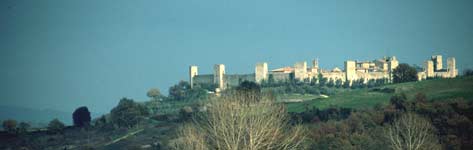
village of Monteriggioni in the Valdelsa. The Sienese erected a defensive
wall here in 1213 to provide protection against Florentine attack. Fourteen
large towers, soaring above the walls, were subsequently built to reinforce
the defences. Even though these have now been lowered, the old defensive
structure which inspired Dante is still apparent. Having
left Master Adam, Dante and Virgil walk across a vast, dark plain to reach
the Well that gives access to the big frozen lake of Cocito. In the twilight,
the poet glimpses the large outlines of Giants positioned around the edge
of the Well. To make the idea clearer to the reader, Dante uses a highly-appropriate
simile; in fact, the position of the Giants reminds him of the fortified
village of Monteriggioni in the Valdelsa. The Sienese erected a defensive
wall here in 1213 to provide protection against Florentine attack. Fourteen
large towers, soaring above the walls, were subsequently built to reinforce
the defences. Even though these have now been lowered, the old defensive
structure which inspired Dante is still apparent.
Però che come sulla cerchia tonda
Montereggion di torri si corona,
così ('n) la proda che 'l pozzo circonda
torreggiavan di mezza la persona
li orribili giganti, [...]
For, as along its walls, encircling high,
Montereggiòn with many a tower is crown'd,
So o'er the Well's round rim, tremendously,
With bodies huge, half rais'd above the mound,
Were towering the Giants, [...]
(Inferno, Canto XXXI, 40/44) |
This walk allows you to get a better idea of the distinctive turreted
outline of the fortified village, taking you over the hills around Monteriggioni,
amidst the vineyards and olive groves that overlook the Torrente Staggia,
which flows into the river Elsa. The route is mainly along narrow roads
and tracks linking farm-holdings, and takes in Monteriggioni, which you
enter through one of the old gates, bringing you into a broad piazza dominated
by the solid walls and ringed by the "giant" towers.
Start from the piazza/car park of Castellina Scalo station. Take the asphalt
road on the left (as you look towards the station) that crosses the railway
line and leads to a more significant road. Go right along this and after
about 200 metres take the first right, a small road that immediately becomes
unpaved. It climbs along the ridge of the hills above the Torrente Staggia,
and enters a cool wood of hardwood trees. At a height of about 250m the
path comes out into the open air, passes the Castellino house and farm
and the turning for the Fattoria di Rencine. Immediately after this you
come to an important junction. Going left will take you uphill to the
isolated medieval village of Rencine, consisting of a number of country
farmhouses and a small church built on a natural balcony with a view of
the Staggia valley. This valley is dominated by the hill on which the
turreted village of Monterrigioni is built. Going straight on takes you
downhill, past the village cemetery and into a wood, then up the hill
where Casa Nuova is situated. Soon you reach a junction in front of Trasqua,
old farm buildings turned into an agriturismo, together with a nearby
campsite. Go right, skirt round the campsite and go downhill towards the
group of rural houses that make up Busona, visible below. When you get
to these, leave the main track and turn right along an unpaved road that
leads towards the farm (a sign prohibits access to cars). Just before
you reach it, however, go right, walk downhill between rows of vines and
cross a small basin. Walk uphill towards the farmhouse of Busoncina, go
round the right-hand side of it, and you'll come to a distinct path running
away from the farm along the ridge.
 Very shortly there's a junction. Go left here, sticking to the ridge
along a mule-track which is slightly overgrown but poses no difficulties.
This path in the woods soon begins to drop down towards the valley bottom,
where you join a wider cart-track. Go right, crossing an open field and
then going by innumerable rows of vines. Stick to this main track till
you come to the railway line. Cross underneath it and you'll come to the
banks of the Staggia. Cross this watercourse, climb for thirty or forty
metres, take a sharp bend to the right and pass underneath the Firenze-Siena
highway. From here on you can't get lost because as you come out from
the underpass you can see Monteriggioni in front of you, which you reach
via the farm roads running between the olives on the hillside. From Monteriggioni,
go back the way you came till you come to the railway underpass. About
100 metres further on, turn left at a junction and walk uphill along the
left-hand side of a vineyard. When you reach the top, go left along a
mule-track that passes through tall patches of broom and enters a beautiful
oak wood. When you come out of this, walk uphill along the edge of another
vineyard, at the end of which you come to a bigger unpaved road. Go left,
crossing through the wood that surrounds the Fattoria di Rencine, and
you soon come to the estate itself. Here there's a good gravel road running
downhill to the road used at the beginning, which leads back to Castellina
Scalo.
| Time required |
4 hours, 30 minutes |
| Vertical height |
320 m |
| Maps |
Multigraphic 1:25.000, "Siena e dintorni" |
| How to get there |
The starting point at Castellina Scalo is
reached from Firenze or Siena by taking the main highway linking
the two cities. Exit at Monteriggioni and then follow the road signs.
It's also on the Firenze-Empoli-Siena railway line. |
|
 Skiing round the Apennine hermitages
 Photo Gallery: The tour