 In
the opening cantos of The Purgatorio, Dante dwells at length on the steepness
of the mountain and the difficulty of the path. Obviously he describes
the ascent of Purgatory as particularly difficult because it's difficult
for man to overcome vice and achieve moral purification. To make his images
more concrete, Dante draws on real locations that he knew, and which in
those days were considered to be some of the most inaccessible: in Canto
III there's the Ligurian coast between Lerici and Turbia (see the introductory
quotation); in Canto IV, San Leo (city of Montefeltro positioned on a
high, rocky pyramid, which in Dante's age could only be reached by a steep,
narrow path cut into the rock); Noli (a Ligurian coastal village between
Savona and Albenga, which backs onto towering, steep, craggy cliffs that
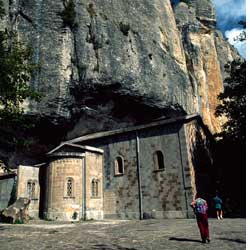
are still today a challenge for descending walkers); and Bismantova, the
famous sheer-sided "rock" that plunges towards the green hills
of Reggio Emilia below. In
the opening cantos of The Purgatorio, Dante dwells at length on the steepness
of the mountain and the difficulty of the path. Obviously he describes
the ascent of Purgatory as particularly difficult because it's difficult
for man to overcome vice and achieve moral purification. To make his images
more concrete, Dante draws on real locations that he knew, and which in
those days were considered to be some of the most inaccessible: in Canto
III there's the Ligurian coast between Lerici and Turbia (see the introductory
quotation); in Canto IV, San Leo (city of Montefeltro positioned on a
high, rocky pyramid, which in Dante's age could only be reached by a steep,
narrow path cut into the rock); Noli (a Ligurian coastal village between
Savona and Albenga, which backs onto towering, steep, craggy cliffs that
are still today a challenge for descending walkers); and Bismantova, the
famous sheer-sided "rock" that plunges towards the green hills
of Reggio Emilia below.
Vassi in Sanleo e discendesi in Noli,
montasi su in Bismantova in cacume
con esso i piè, ma qui convien ch'om voli;
Men down to Noli, up to San Leo high,
E'en to Bismantua's peak, are seen to go,
Afoot; but here a man needs wings to fly
(Purgatorio, Canto IV, 25/27) |
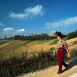
Of the places mentioned by Dante in these cantos, we chose the last
two because they lend themselves best to good long walks. The route to
Noli, in particular, is along ancient paths that still cut across the
rocky slopes of Capo Noli and detour to take in a nearby and very interesting
mountain plain, the Altipiano delle Manie.
From Varigotti, walk along the shoreline in the direction of Savona, and
at the beginning of the climb towards Puta Crena, you'll see a narrow
road on the left that climbs and runs behind the uppermost houses in the
village. Look out for a mule-track on the left-hand side marked with FIE
signs (a red X), which climbs in the direction of the Chiesa di S. Lorenzo.
This mule-track was the old route across Capo Noli, and large sections
of it are still quite wide, well-paved and stepped. After a few hundred
metres, you come to a junction. If you go right, you come to the 11th-century
Chiesa di S. Lorenzo with a panoramic view of the beaches and cliffs of
Capo Noli. Going straight on, climbing quite steeply, follow the mule-track
that climbs the southern slope of the promontory, crossing areas of botanical
interest characterized by luxurious Mediterranean vegetation. Ignoring
a blue-marked path off to the left, you soon come to a junction. If you
go right (yellow-marked path), you can get to the medieval tower of Varigotti,
an old watchtower overlooking the Ligurian Sea. Carry on along the main
mule-track which climbs to an unpaved road linking the Manie with the
coastguard station of Capo Noli. Go right along this but after 100 metres
you come to a gate marking the entrance to a military zone. Turn left
here along an unpaved track. After about 300 metres turn off to the left
along a narrow path that descends steeply to Noli, falling approximately
200 metres in altitude in just over a kilometre.
 From
Noli, walk up the same path till you get to the unpaved road of the coastguard
station. Go right along this and stick to it, ignoring the marked paths
that go off downhill to the left towards Varigotti (which you can use
if you want to get back to your starting point directly) and to the right
towards Noli. The unpaved road finally joins the surfaced road of the
Altipiani delle Manie. Turn right and walk along it for approximately
200 metres. Take the first unpaved road to the left and walk along to
the Chiesa di S. Giacomo and from there to Arma, near which there is a
famous cave once inhabited by pre-historic Man. From
Noli, walk up the same path till you get to the unpaved road of the coastguard
station. Go right along this and stick to it, ignoring the marked paths
that go off downhill to the left towards Varigotti (which you can use
if you want to get back to your starting point directly) and to the right
towards Noli. The unpaved road finally joins the surfaced road of the
Altipiani delle Manie. Turn right and walk along it for approximately
200 metres. Take the first unpaved road to the left and walk along to
the Chiesa di S. Giacomo and from there to Arma, near which there is a
famous cave once inhabited by pre-historic Man.
Having retraced your steps to S. Giacomo, go right, cross a small bridge
and walk uphill along an unsurfaced road till you come to a surfaced one
near a cemetery. Go left along this and walk along as far as a wide curve
to the left. Here, on the right, is a beautiful, sign-posted path for
Varigotti which takes you back to your starting point with no possibility
of getting lost.
| Time required |
4 hours |
| Vertical height |
580 m |
| Maps |
Multigraphic 1:25.000, no. 103/104 "Alpi
Marittime e Liguri" |
| How to get there |
Varigotti can be reached from Genoa and
Savona along SS. 1 Aurelia in the direction of Imperia. |
|

 Skiing round the Apennine hermitages
 Photo Gallery: The tour