 The
Pietra di Bismantova, recalled by Dante in Canto IV of The Purgatorio
(see walk number 5) is a highly-distinctive and solitary monolith rising
up amidst the hills running down from the Apennines towards the Emilian
plain. This route takes you first to the panoramic cacume, that is the
highest point on the edge of the cliff-face, and then skirts round the
mountain along quiet mule-tracks that run along the foot of the mountain. The
Pietra di Bismantova, recalled by Dante in Canto IV of The Purgatorio
(see walk number 5) is a highly-distinctive and solitary monolith rising
up amidst the hills running down from the Apennines towards the Emilian
plain. This route takes you first to the panoramic cacume, that is the
highest point on the edge of the cliff-face, and then skirts round the
mountain along quiet mule-tracks that run along the foot of the mountain.
On the main road to Campolungo you can see the red and white signs of
the Spallanzani footpath; these signals take you uphill along a poorly-maintained
surfaced road. Soon afterwards, turn right off the asphalt road onto a
track that climbs amidst extensive fields used for pasture. This track
joins an unpaved road leading to Fontana Cornia; go right along this,
and soon afterwards turn off to the left along the marked footpath that
runs across the eastern slopes of the Pietra di Bismantova. When you reach
a significant junction, go left along the clear path that runs beneath
the massive, vertical cliff-face of the Pietra.
 From
here on the route is very clear, first along a footpath and then on an
unsurfaced road. This finally joins a surfaced road; go right along this
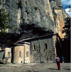
and it climbs to a car park. Take the stone steps that lead up to a wide
piazza in front of the hermitage, an interesting building embedded in
the rock of the Pietra di Bismantova. Go left from the piazza, joining
a wide mule-track that begins to skirt round the western spur of the mountain.
After a long, almost level stretch, the mule-track begins to climb until
it reaches a grassy plateau. Go right here and follow the twisting path
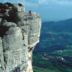
up to the high plateau. Crossing this you come to the edge of the cliff-face
of the Pietra di Bismantova. Here you can see the beautiful panoramic
path that runs along the crest of the mountain near the cliff edge. Sticking
to the main path, you soon begin to descend till you come to a wide mule-track.
Turn right and continue downhill, and the track gradually becomes a cart-track.
Be on the lookout for a left-hand bend that heads towards some farm buildings.
Three hundred metres before these buildings, go right along the narrow
mule-track that leads to the Spallanzani footpath. This takes you back
downhill to Campolungo. From
here on the route is very clear, first along a footpath and then on an
unsurfaced road. This finally joins a surfaced road; go right along this
and it climbs to a car park. Take the stone steps that lead up to a wide
piazza in front of the hermitage, an interesting building embedded in
the rock of the Pietra di Bismantova. Go left from the piazza, joining
a wide mule-track that begins to skirt round the western spur of the mountain.
After a long, almost level stretch, the mule-track begins to climb until
it reaches a grassy plateau. Go right here and follow the twisting path
up to the high plateau. Crossing this you come to the edge of the cliff-face
of the Pietra di Bismantova. Here you can see the beautiful panoramic
path that runs along the crest of the mountain near the cliff edge. Sticking
to the main path, you soon begin to descend till you come to a wide mule-track.
Turn right and continue downhill, and the track gradually becomes a cart-track.
Be on the lookout for a left-hand bend that heads towards some farm buildings.
Three hundred metres before these buildings, go right along the narrow
mule-track that leads to the Spallanzani footpath. This takes you back
downhill to Campolungo.
| Time required |
2 hours, 30 minutes |
| Vertical height |
410 m |
| Maps |
Multigraphic 1:25.000, no. 14/16 "Appennino
Toscoemiliano" |
| How to get there |
Campolungo can be reached from Reggio Emilia
along the SS. 63 for the Passo del Cerreto in the direction of Castelnovo
ne' Monti. Shortly before arriving in Castelnovo, follow the road
signs and you soon arrive at Campolungo. |
|
 www.terraditoscana.com